
We have been imagining how to recreate the Sunset district of San Francisco, in a way that not only adds multiples of new living space, but also results in a much more pleasant, liveable (and affordable) result than what is there today.
May 31, 2020: Sunset 2.0
June 21, 2020: Sunset 2.0 #2: Streets and Buildings
Basically, we are using our Traditional City design methods, which also happens to be right in line with the proposals of the recent SB50 bill. Some of our conclusions thus far:
The basic building structure will be an apartment or townhouse of 3-6 stories high, a common Traditional City solution throughout the world and especially in Europe. In most cases, this will be of a Courtyard or Backyard format. We are generally aiming for a total building footprint/total surface area ratio of about 50%. Sometimes, we see this ratio approaching 90%, as is common in Italy — and this is not perceived to be unpleasant. But, we are allowing quite a lot of area (about 40% of all land surface area) for public and private outdoor parks, courtyards and gardens. One reason for the Courtyard or Backyard format is because the streets are rather widely spaced, reflecting the common patterns of Nineteenth Century Hypertrophism. If you had 100 feet between streets, you could have a 40′ deep building and a 10′ backyard. However, with 200 feet between streets (and we will be closer to 250 feet when we reduce the width of the public right-of-way), we tend toward Courtyard patterns to make use of that space, or perhaps sub-streets to provide access to block interiors.
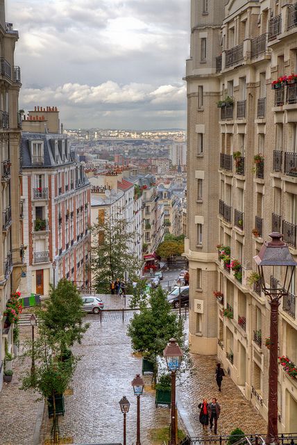
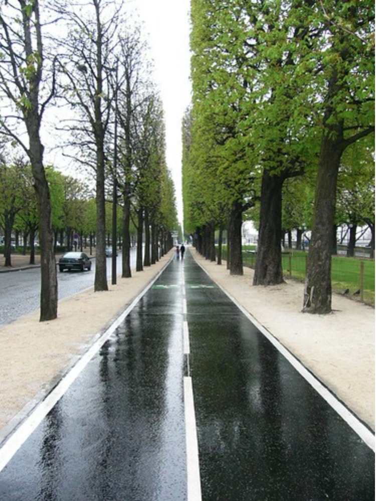
5-6 story buildings on a street of about 40 feet wide. Paris, France. Despite the width, this street is “For People” (approximately) — it is one flat plane from one side to the other, without a clear segregation of an section “for vehicles” in the middle, the typical pattern of the Arterial Street.
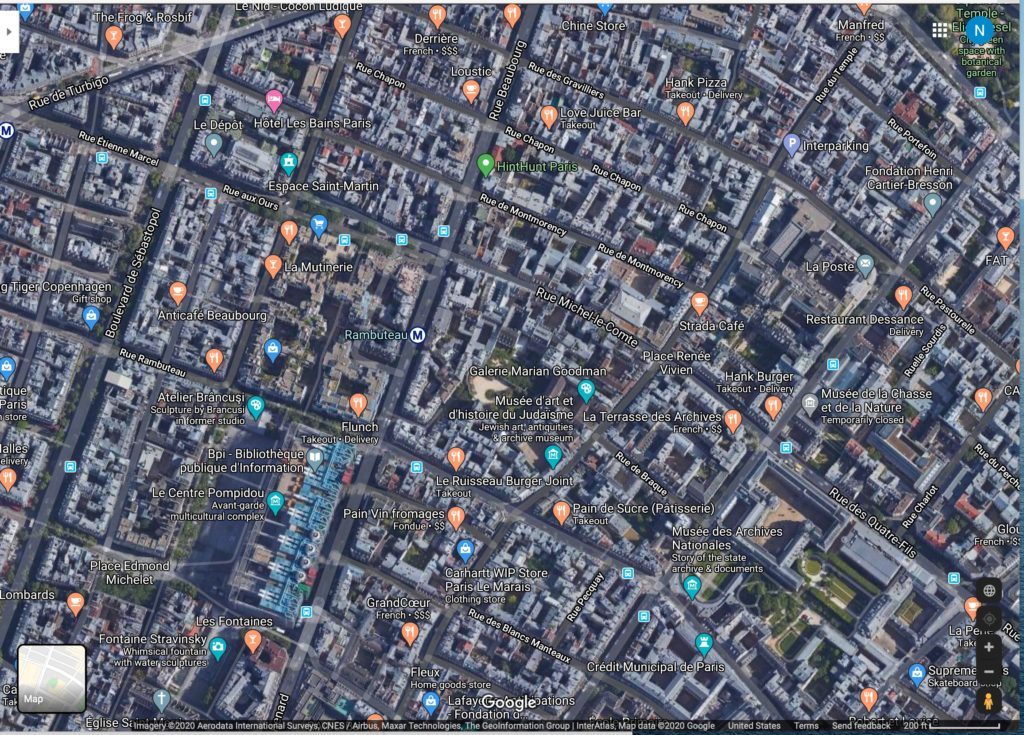
This aerial view of Paris shows the Courtyard pattern typical in that city.
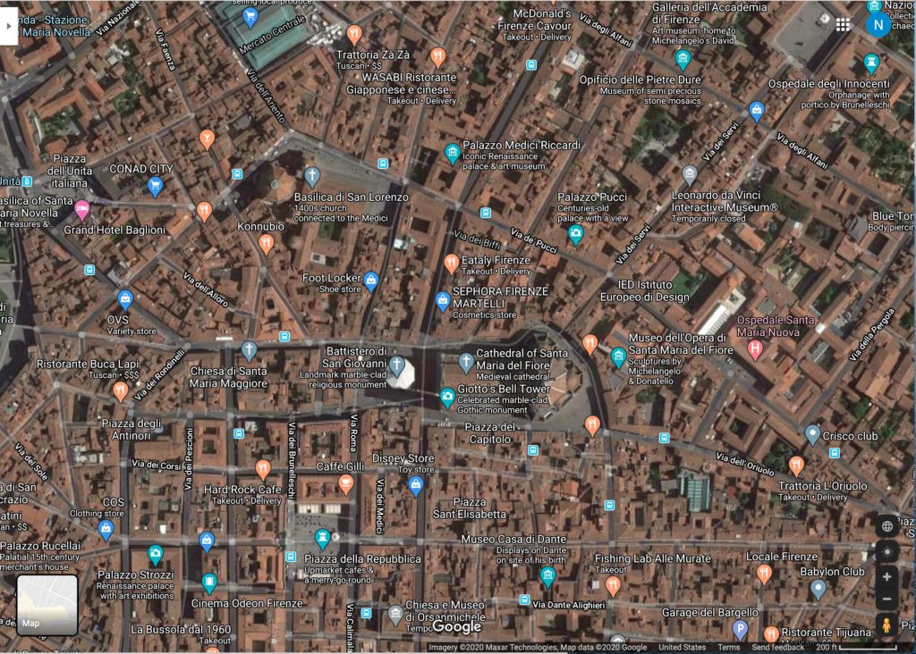
This aerial view of Florence, Italy shows the very high building footprint/total area ratio, nearing 90%, common in classic Italian cities. Thousands of Americans visit there every year, and you never hear anyone complaining about a “lack of Green Space.” Nevertheless, we will follow more of a Paris model, which has a lot of room for parks and gardens.
Many of the Streets in our renovated Sunset district will be For People: that is, a flat plane from one side to the other, where people feel comfortable walking down the middle of the street. Typically, these are 10-50 feet wide. I have proposed streets more toward the wide end of this range, like this:

That is mostly not to rattle people’s cages too much. But, for these Streets for People, we could go narrower than that, and not only get more land for buildings and parks, but also, get a better result overall for the street. Wider is not better here.

Zurich, Switzerland. This is about 20 feet, and it is still wide enough to use some of the space for outdoor restaurant seating.
Some of the streets will remain in the Arterial form that they are now, with a central segregated roadway for vehicles. So, there will be no place that is more than a few hundred meters from a vehicle roadway.

Arterial in London, England.
These Arterials will be quite wide (remaining much as they are today), and have plenty of space for segregated bicycle lanes, streetcars, etc.
April 13, 2014: Arterial Streets and Grand Boulevards
I proposed that perhaps one out of five north-south streets will be Arterials, and the rest will be Streets for People. Perhaps one of two east-west streets will be Arterials.
Now, let’s take up the topic of transportation.
Our proposed building pattern will increase the floor area by 2-5 times. There could be 2-5 times more people living in the Sunset district. The immediate reaction of most people is that it would be “crowded,” and thus, unpleasant. But, the main problem with that number of people (which is actually still not very high) is automobiles. When you have more automobiles (not more people), this can get unpleasant.
There are not a lot of good reasons to have a private automobile in the Sunset district. It does not have good access to highways or the rest of the city. If you wanted to get anywhere else in San Francisco, you would probably be better off taking the streetcar/bus/BART subway system. Plus, owning an automobile costs a lot of money. Besides the regular expenses of owning a car (which are not trivial), you would have to pay a lot for parking — perhaps as much as $400 a month. We will not provide any free or subsidized onstreet or offstreet parking, so all car-owners would have to pay a full market rate.
July 30, 2018: The High Cost of Free Parking
August 5, 2018: How Much Should Parking Cost?
There are a few people who need an automobile for work. These include people whose jobs are not in one place, but who have to travel here and there. This might include salesmen or lawyers. Also, it might include people that need a vehicle as part of their work. This would include tradesmen who must carry tools and building materials. But, these people do not have to live in the Sunset District. There are many, many other places for them to live, that would be much more appropriate for their needs.
Some people probably perceive the need for an automobile for day-to-day living. They imagine that they have to drop off their children at school, or buy groceries.
But, one advantage of having 2-5 times as many people, is that you also get 2-5 times as many schools and grocery stores. The result is that all these things are in easy walking distance. You can easily combine retail/commercial and residential in some neighborhoods, with the common pattern of having retail at ground level and apartments above. Other neighborhoods may have residential only, which would be quieter.
Now, we have 2-5 times as many people, and also, nearly all these people live without a car. We have a very large market for transportation services.
Immediately, we have a large market for people who might want to get out of town. They want to go to Yosemite in the summer or Tahoe to ski in the winter, or to go to West Marin for a Saturday afternoon. This creates the demand for extensive bus service out of town. You no longer need your own car to do those things. You can have a beer and let someone else take care of the driving after your ski weekend in Tahoe. Or, you might find that places that are accessible via transit (for example, via the BART or the CalTrain system) become highly desirable, and thus there is development of amenities around existing train stations. But, also, since the Sunset District itself is now much more pleasant and fun (we also have 2-5 times more bars and restaurants; and we haven’t even begun to talk about the beach and Golden Gate Park yet), people who live there have much less interest in going somewhere else in their free time. The Sunset District might even become a major destination itself. I can imagine that, in a Chinese tourist’s guidebook, it would soon be identified as the most interesting part of San Francisco.

La Rambla, Barcelona, Spain.
We will leave aside for now the possibility of heavy passenger rail, such as dedicated subways connecting directly to the existing BART system. Unfortunately, it seems that we cannot build at that level today. So, let’s stick with the existing MUNI streetcar system, and also, perhaps add more streetcar lines.
When you have more passengers, you can run more trains per hour, which makes the whole system better for everyone. Also, you have more passengers to fund the basic fixed-cost infrastructure of rails and stations, which makes the system financially healthier and keeps ticket prices low. And, you can add more lines, which means that you can more easily travel throughout the area using the streetcar system. All good. Transit systems scale well — that is, as they get bigger and bigger, they get better and better.
(MUNI has a problem today with the stations/stops being too close together, which increases travel times. Stations/stops should be at least 800 meters apart.)
To this streetcar system, we will add an extensive network of dedicated, segregated bicycle lanes. These will be on Arterials. There is no need for segregation on Streets for People, although bicycles can still travel there, mixing freely (at low speed) with pedestrians. The bicycle lanes on Arterials should be separated from any vehicles (and streetcars) with physical barriers. Like this:
The best segregation would be a row of trees, which does not take too much space and also adds some nice street trees to our otherwise rather barren Arterials.

Bicycle lane map of the Netherlands.
The Arterials that have streetcars can become Transit Arterials — streets that have streetcars, bicycles and sidewalks, but no lanes for vehicles.
We can also use buses, such as the Muni bus lines that already exist. But, with more passengers, we could replace those bus lines with streetcars, which are much nicer. No more buses. Or, we can have dedicated bus lanes, essentially Bus Rapid Transit, which amounts to much the same thing as a streetcar line but with buses.
We will allow access for necessary commercial vehicles, for pickup and delivery, taxis, trash collection, construction, emergency response and so forth. But, what we find is that these needs do not actually generate very much traffic. This street in Milan, Italy, probably has trucks come by from time to time to remove trash or deliver packages or a sofa. But, as you can see, this does not create a constant crush of “traffic.”

Street in Milan, Italy. They use trucks there too. No oxcarts.
If you wanted to get a little serious about it — sometimes Americans do this — you could not only discourage private automobile ownership (which happens naturally when you stop subsidizing it with free parking), but ban it outright in the Sunset district. The easiest way to do this is to simply eliminate parking, including private parking. You can still allow taxis, limos, and so forth, along with commercial vehicles such as trucks and vans. This is perhaps a little extreme, but it should also eliminate fears of excessive auto traffic arising from the planned increase in population. People who really, really need a car can simply live somewhere else in San Francisco.
To summarize, our transportation plan looks like this:
Walking: With much higher population density, you can support many more supermarkets, shops, schools etc., which means there is much more within an easy 10 minute walk. In many cases, you might have retail on the ground floor below your apartment.
Streetcars: Much higher ridership means more trains per hour, and also, new streetcar lines. At some point, we could include subways connecting to the existing BART network.
Bicycles: An extensive network of segregated bicycle lanes on Arterials, plus easy access on all Streets for People. Plus, we can have bikeshare, and bicycle-like devices like electric scooters.
Buses: We could replace the existing bus lines with streetcars, but if not, we can also have bus lines.
Taxis: Walk to the nearest Arterial and get a taxi, if that floats your boat. Includes Limos, for VIPs who refuse to ride transit.
Commercial vehicles: Trucks and vans, for pickup and delivery, and other heavy commercial jobs.
Rental Cars: Want to get out of town for a weekend? Rent a car.

Arterial Street in Zurich, Switzerland, with Streecars but no lanes for vehicles.

Arterial in Bern, Switzerland, with streetcars and no vehicle lanes.

Street for People in Zurich, Switzerland. 4-5 story building height. We are looking at perhaps 4-6 times the population density of the Sunset district as it exists today. Nice, don’t you think? Do you think people living on this street own automobiles? Do they care? It looks like they can walk downstairs and buy marijuana, which might be nice.

Street for People in Zurich, Switzerland. 4-6 story building height.

Arterial in Zurich with streetcars but no lanes for vehicles.

Bicycle lane on an Arterial, segregated by street trees. Ontario, Canada.

Bus Rapid Transit in Cambridgeshire, England.

Dedicated Bus Arterial in Bogota, Colombia.

Segregated bicycle lane on an Arterial in Oklahoma City, Oklahoma.
